2024 UK's fourth warmest year on record

- Published
Despite the UK mostly escaping the extreme heat seen in recent years, 2024 was still hotter than it might have seemed.
According to their latest analysis, the Met Office say it was provisionally the fourth warmest year on record, behind 2022, 2023 and 2014.
All ten of the top warmest years have occurred since the year 2000, with five in the most recent decade 2015-2024.
Here are five of the biggest weather moments from last year.
The year got off to a stormy start

The 2023/24 storm season saw 12 named storms, the greatest number of named storms since the first season in 2015/16
Storm Henk battered the UK in early January, followed by Storms Isha and Jocelyn arriving three weeks later.
Isha was the most significant windstorm to impact the UK since Storm Eunice in February 2022. Widespread damage on 21–22 January left hundreds of thousands without power across Ireland and the UK, with flights cancelled and train services disrupted nationwide from Scotland to London.
The Met Office issued a rare red warning for wind in parts of north-east Scotland and gusts peaked at 99mph (159km/h) in Northumberland, while extensive amber warnings covered more than half of the UK.
Aside from the stormy weather and despite occasional cold spells, a new UK January maximum temperature record of 19.9C was set in Achfary, Sutherland at the end of the month.
February was a record breaker
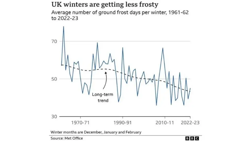
The trend in the UK is for less frost in winter
The UK's temperature in February was 2.2C above the climate average, making it the second warmest February since 1884, behind 1998, but the warmest on record for England and Wales.
Despite a brief cold spell in northern parts of the UK early in the month, it was one of the least frosty winters on record. Southern England also saw its wettest February, with rainfall reaching 239% of the average.
These patterns align with long-term warming trends in the UK's climate, where a warmer climate is associated with more frequent spells of wet weather.
Spectacular displays of the Northern Lights

Londoners were treated to a rare glimpse of the Northern Lights, a stunning display that managed to shine through the city's usual light pollution
Despite changeable conditions, the UK recorded its warmest May on record, with temperatures 2.4C above average - surpassing the previous 2008 record by a full degree.
A brief spell of clear weather this month was particularly well-timed and coincided with the the most widespread aurora display across the UK and many parts of the northern hemisphere since 2003.
Sky watchers across the nation were captivated as the aurora shone brightly, even piercing through London's intense light pollution.
However, after a mild May, many were reaching for jackets just as summer seemed imminent. A blast of cold northerly winds carrying Arctic air brought an unseasonably chilly start to June, with temperatures 2C below average - a reminder that occasional cold spells can still occur, even as our climate continues to warm.
- Published7 January
- Published11 October 2024
- Published8 October 2024
Coolest summer in nine years

Beachgoers enjoyed the weather on the warmest day of the year at Southend-on-Sea in Essex
Summer 2024 was the UK's coolest since 2015.
Mean temperatures in June and July were slightly below average across the UK, driven by a south-shifted jet stream that brought northerly winds carrying Arctic air.
August saw warmer conditions but it was also the wettest of the three summer months, though with significant regional variation.
Despite this, brief spells of heat occurred in parts of the UK, with the summer's highest temperature of 34.8C recorded in Cambridge on 22 August.
Tumultuous end to the year

Residents of Pontypridd in Rhondda Cynon Taf were forced to bail water to protect properties during a severe flood
The end of November was marked by a brief but significant cold snap, delivering the season's first notable snowfall to parts of the UK, from Scotland to Devon.
Temperatures dropped below -10C in some areas of northern Scotland, including Braemar in Aberdeenshire, which recorded a low of -11.2C, the coldest November night since 1998.
Shortly after, the weather turned extremely wet and windy as Storm Bert brought its most severe impacts to South Wales. The River Taff burst its banks in Pontypridd, causing severe flooding, with more than 150mm (6in) recorded between 23–24 November.
Less than two weeks later, Storm Darragh arrived, bringing widespread damage and disruption. The Met Office issued a rare red warning for wind ahead of the storm.
Land gales battered much of UK with winds exceeded 90mph (145km/h) along the Welsh and Devon coasts. At one point, 200,000 homes across the UK lost power, according to the Energy Networks Association.
For all the weather in 2025, check your latest forecast here or on the BBC Weather app.
- Published17 October 2024
- Published21 January
- Published5 December 2024

Sign up for our Future Earth newsletter to get exclusive insight on the latest climate and environment news from the BBC's Climate Editor Justin Rowlatt, delivered to your inbox every week. Outside the UK? Sign up to our international newsletter here.