What do you know?
What is the longest river in the world?
At 4,130 miles (6,650 km) long, the Nile in Africa is the longest river in the world. Some people consider the Amazon in South America to be longer. This is because the many hundreds of channels that make up the Amazon cover around 4,300 miles (7,000km) when they are added together.
Key points
- Rivers form part of the water cycle. They are a downward flow of water, under the force of gravity.
- Rivers shape the land through erosion, transportation and deposition. These processes create distinctive landforms.
- In the upper course, vertical erosion creates waterfalls and v-shaped valleys. In the middle course and lower courses, lateral erosion creates meander bends, oxbow lakes and deltas.
What is a river?
The water cycle
The hydrological cycle, or water cycle, shows the movement of water between the The air surrounding us. The atmosphere contains the gases that we breathe and is the place where our weather happens., land and oceans. Rivers form part of the hydrological cycle.
- Energy from the Sun heats the surface of the Earth.
- Water is The process in which a liquid changes state and turns into a gas. from oceans, rivers, lakes, etc.
- The warm, moist air rises because it is less dense.
- occurs when water vapour is turned back into water droplets as it cools down. Clouds are formed.
- Any moisture that falls from the clouds, such as snow, rain, hail and sleet. occurs as water droplets get bigger and heavier they begin to fall as rain, snow and sleet, etc.
The long profile
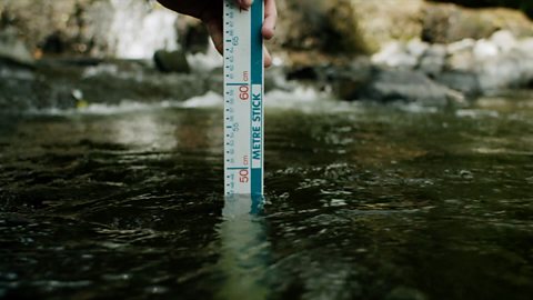
Rivers transport water downwards because of Gravity is a force that pulls all things toward one another. We commonly experience gravity by being pulled downwards by the Earth.. As they move further downhill, they gather more water and become larger. Rivers can be divided into three sections: the upper, middle and lower courses. Together, these three courses form the A line representing the path of a river from where it starts (the source) to where it ends (the mouth)..
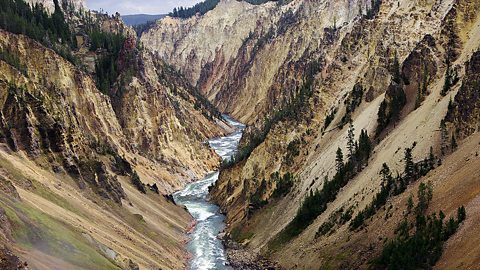
- Upper course – The start of the river at higher The height of the land, measured in relation to sea level.. The river channel is small. Vertical, or downwards, Wearing away of the land by natural forces such as water or wind. takes place here as water is pulled down by gravity.
- Middle course – The middle section of the river. Smaller river channels that flow into larger rivers. have joined the channel and so the river is carrying more water.
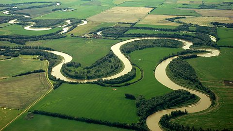
- Lower course – The final stage of the river, usually where it meets the sea. The river is wide and deep because it is carrying a large volume of water. The wearing away of the land in a sideways motion. Lateral erosion happens at lower altitudes, such as places that lie close to sea level., or sideways, erosion and When water, that is carrying sediment (small fragments of rocks and soil), loses its energy it drops the material it is carrying. This often builds up to form a beach. takes place here.
Question
Where does vertical erosion take place?
Vertical erosion takes place at high altitudes. Gravity pulls water down and so the land erodes in a downwards direction.
What are river processes?
Rivers shape the land by moving material from one place to another through erosion, transportation and deposition.
Erosion
When material is removed from the riverbed and banks. There are four types of river erosion:
- Attrition – rocks carried by the river collide. They break up into smaller, smoother pieces.
- Abrasion – rocks carried by the river scrape along the bed and banks. This loosens material, which is then carried away by the water in the river.
- Solution – Something that dissolves, for example limestone dissolves in slightly acidic water. particles are dissolved by the river.
- Hydraulic action - the force of the river against the banks. Air becomes compressed within cracks and crevices, which weakens the banks.
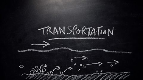
Transportation
When material is moved further downstream. There are four types of transportation:
- Suspension – smaller material that is light enough to be continuously carried along.
- Traction – large rocks are rolled along the riverbed at times of high energy, eg when the river level is high.
- Solution – very small material that is dissolved and can be transported even during times of low energy.
- Saltation – the water picks up rocks and pebbles. They are too heavy to be carried far and so they appear to bounce along the riverbed.
Deposition
When material is dropped by the river.
Deposition happens when river energy is low, for example when the flow of the water slows down. It can happen along any part of the river, but is common in the lower course, where the river meets the sea. Larger, heavier material is deposited first. Smaller, lighter material can often be carried during times of low energy.
Question
What transportation process moves the largest rocks in a river?
Traction moves the largest rocks in a river. Traction happens when large rocks are rolled along the riverbed at times of high energy.
What are river landforms?
Different landforms are located along the river long profile.
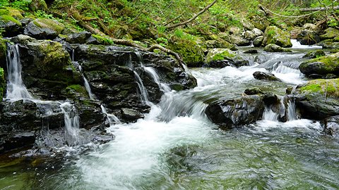
Image caption, Waterfalls and rapids
Waterfalls and rapids are found in the upper course. These form when rivers flow over hard and soft rock. Vertical erosion wears away soft rock, forming rapids and waterfalls.


1 of 6
Question
Name one landform found in the upper course of a river.
Waterfalls, rapids and v-shaped valleys are all landforms found in the upper course of a river. They all form as a result of vertical erosion.
Test your knowledge
GCSE exam dates 2025
Find out everything you need to know about the 2025 GCSE exams including dates, timetables and changes to exams to get your revision in shape.

More on Rivers and Water
Find out more by working through a topic
- count1 of 4
- count2 of 4
- count3 of 4