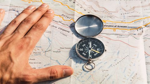
What do you know?
What is an atlas?
An atlas is a collection of different maps at different scales, usually presented in a physical book.
Key points
- Atlases show a variety of different maps at different scales.
- Atlases can be used to show physical, political or thematic information.
- Although atlases are useful, they do have certain limitations.
What is an atlas?
An atlas is a book that shows a variety of different maps at different scales. They usually contain maps of the world, continents and countries. The maps they include can be Natural features of the land., Maps which show national boundaries and major urban areas. or Maps which show information on a certain topic or theme. :
- Physical maps show the natural features of the land such as mountains, rivers and lakes.
- Political maps show national boundaries and major urban areas such as towns and cities.
- Thematic maps show information on a particular theme, such as rainfall, levels of wealth or the location of biomes. These may be presented as A map that is shaded in one colour eg different shades of red, according to a range of values presented in a key..
In addition to this, atlases often include other relevant information such as tables of statistics for countries, such as life expectancy or measures of wealth.
Limitations of atlases
Although atlases are a valuable resource, they do have limitations, especially when compared to Specialist software which links geographical data to create layers of digital maps to display information. (GIS) such as those found online. It would be impossible to include the same amount of detail in an atlas as we can online. We can't zoom in to an atlas to view a place at street level, for example. Nor can we add or remove layers such as A photograph of the Earth’s surface taken from the air. . As with all maps, atlases become outdated very quickly but they can't be as easily updated as online versions.
The Mercator projection
Another limitation of an atlas is that as maps are flat, and the world is A 3D shape that is round, like a ball. , all maps are The misrepresentation of a shape, area, distance, or direction of or between geographic features when compared to their true measurements on the curved surface of the Earth.. The A way of flattening the world’s surface so as to make a map. we normally use is called the A type of map widely used.. This has some advantages over other projections but it has been criticised for influencing people's A person’s way of thinking about and understanding life. A persons’ worldview will vary depending on their beliefs, experiences and attitudes. as it makes landmasses far from the equator seem larger than they really are. For example, on a Mercator projection, Greenland appears to be the same size as the continent of Africa, when in reality Africa is 14 times larger.
The Peters World Map
Another projection sometimes used is known as The Peters World Map or the Gall-Peters projection. In this projection, landmasses are the correct size relative to each other. However, these are still distorted, with areas stretched near the An imaginary line that runs around the Earth. The equator marks the dividing line between the Northern and Southern hemispheres. and squashed at the poles.
Question
What are the three types of maps usually found in an atlas?
Physical, political and thematic maps can usually be found in an atlas.
Finding locations in an atlas
Atlases always contain a table of contents and an index which makes it easier to find a specific map or place.
Table of contents
The table of contents is found at the front of the atlas and lists the main sections included in the atlas in order of page number. These sections are usually divided up by continent but there may be other sections such as satellite imagery or tables of statistics.
Index
The index is found at the back of the atlas and lists towns, cities, countries and continents in alphabetical order. Next to each place name is a list of all the pages in the atlas this location can be found. Often a town or city will appear on multiple maps at different scales and covering different topics.
Quiz: Using an atlas
Latitude and longitude
Video: Latitude and longitude
Latitude and longitude
Latitude and longitude
On a globe or map, there are a series of lines. These are the lines of latitude and longitude.
The main line of latitude is the Equator, located at zero degrees latitude, halfway between the North and South Poles. North of the Equator is the Tropic of Cancer and north of that is the Arctic Circle.
South of the Equator is the Tropic of Capricorn and south of that, the Antarctic Circle.
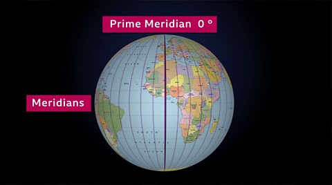
Lines of longitude are known as Meridians and they run from the North Pole to the South Pole. The Prime Meridian is located at zero degrees longitude.
The International Date Line is at 180 degrees longitude.
Both latitude and longitude are measured in degrees and minutes and are used as geographical coordinates to pinpoint the precise location of any place on Earth.
Next to each location in an atlas index, you will usually also find its latitude and longitude Coordinates show a position of a point or points on a grid..
World maps are divided into a grid which shows Imaginary lines that run east to west around the Earth, parallel to the Equator or 0° latitude. They can be measured in degrees (°). and Imaginary lines that run north to south around the Earth, parallel to the Greenwich Meridian or 0° longitude. They can be measured in degrees (°).. Latitude and longitude are measurements of an angular distance measured in degrees. They are shown using the symbol °. As in maths, each degree is then divided into 60 When measuring angles, a minute is 1/60th of a degree. shown using the ' symbol.
The city of Liverpool, for example, is 53 degrees and 24 minutes north of the Equator (0° latitude) written as 53°24'N, and 2 degrees and 58 minutes west of the Prime Meridian (0° longitude) written as 2°58'W. Liverpool's location can therefore be written as 53°24'N, 2°58'W.
Quiz: Which line of latitude are you?
Latitude
Some of the lines of latitude on a world map have names. There are five major lines of latitude:
- the Arctic Circle (66.5°N)
- the Tropic of Cancer (23.5°N)
- the Equator (0°N)
- the Tropic of Capricorn (23.5°S)
- the Antarctic circle (66.5°S)
Longitude
There are only two named lines of longitude. These are the Prime or Greenwich Meridian which is at 0° and the International Date Line which is roughly 180°. When you cross the International Date Line the day and date changes, either forward or backward one day, depending on which way you travel.
For example, if a ship sails east across the Pacific Ocean and crosses the International Date Line on May 5th, the date will jump backward to May 4th. If however the ship was sailing west on May 5th and crossed the line, the date would jump forward to May 6th.
Question
What is the name of the line of latitude found at 0°?
The Equator is the line of latitude at 0°.
Quiz: Latitude and longitude
GCSE exam dates 2025
Find out everything you need to know about the 2025 GCSE exams including dates, timetables and changes to exams to get your revision in shape.

More on Geographical skills
Find out more by working through a topic
- count9 of 10
- count1 of 10
- count2 of 10