Shaping the landscape
As we look at the surface of Northern Ireland we know that there are a number of processes that have helped shape the history of the landscape – from volcanoes, rivers, the weather and the impact of ice sheets and glaciers on the landscape.
The fact that Ireland used to be completely covered in ice a long time ago shows us that climate change is not a new thing and that as climates change, the landscape can be changed quickly.
Watch: Impact of ice and glaciers on NI
Max Heartrate explains the impact of ice and glaciers on the landscape in Northern Ireland.
DIRECTOR: Standby on the floor.
DIRECTOR: Coming to you camera two.
DIRECTOR: Cue on two.
DIRECTOR: Mix-through.
MAX: No time for that! Hello! I’m Max Heartrate and this is Knowledge Express. Information faster than a sasquatch on a ski jump. And today’s topic is….
MAX: Ice ice baby! Glacial features account for some of the most beautiful scenery on this island. They were formed by the last Ice Age 10,000 to 20,000 years ago.
MAX: THAT’S INSANE!
MAX: As it melted, the movement of enormous chunks of ice left behind the landscape that we recognise today.
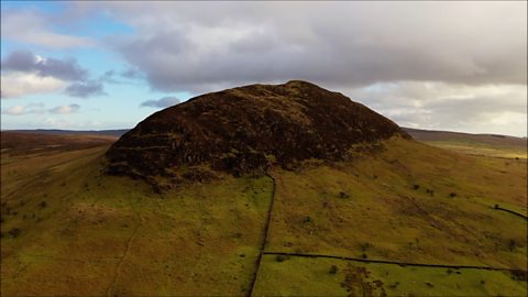
MAX: Take County Down (go on, take it I dare you!), it’s famous for its Drumlins – little elongated hills in the shape of an inverted spoon or half-buried egg. These were formed by glacial ice acting on underlying ground as it melted away.
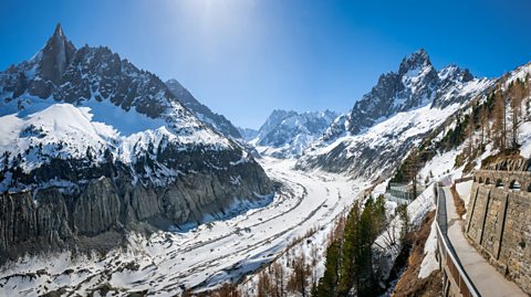
MAX: Meanwhile, up north in County Antrim the world-famous Glens were being carved out by humungous passing ice sheets. Glacial erosion on a massive scale!
MAX: Meanwhile, a few hundred miles south in MacGillycuddy’s Reeks. I’ll say that again – MacGillyguddy’s Reeks! Where the rocks are over three hundred million years old. That’s completely insane! The ice was splitting the sandstone rocks and creating deep armchair like hollows called corries such as the Eagle’s Nest on Carrauntoohil mountain in Kerry.
MAX: And ‘what was happening in the middle of the island?’ I hear you ask. Good question my friends. The more informed of you will realise that the middle part of Ireland is a bit flat. When it comes to glaciation, this is known as the Central Plain where different drift material was deposited creating gently undulating hills or hummocky ground. Where water couldn’t drain away, lakes often turned into peat bogs in what today we call the Shannon Basin. Drumlins, corries, glens and plains – ‘sure where would you get it?’
What are glaciers and when was the last ice age?
- The last ice age in Ireland and the UK reached its peak 18 000 years ago.
- At this time, temperatures remained low the whole year and a large ice sheet containing lots of glaciers covered most of the UK and Ireland.
- Glaciers are rivers of ice that usually start as snow and ice and gather in upland areas.
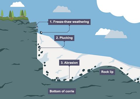
- A Corrie is an armchair-shaped hollow in the mountains.
- When they fill up with enough compacted snow and ice, they will spill out of their hollows and flow downhill to form a valley glacier.
- Over time glaciers will erode the floor of the valley creating a wide U-shaped valley.
- The glaciers will be moved downhill slowly by gravity until they reach a flat plain.
How have glaciers helped shape Northern Ireland?
Most glaciers happen high up in the mountains. As layers of snow and ice start to gather, other weathering and erosion processes will be at work to start causing much bigger erosive features:
| Freeze thaw weathering | Also known as frost shattering. Water found in cracks in rocks freezes and expands. This puts pressure on the rocks. widening these cracks. If the water freezes and thaws repeatedly then bits of rock start to break away and fall onto the glacier. |
| Plucking | This is when rocks are frozen into the bottom and sides of the glacier. As the glacier moves downhill it ‘plucks’ the rocks from the surface of the ground. This can leave a more jagged landscape. |
| Abrasion | A type of erosion that happens as the rocks are dragged and rolled as the glacier moves. The rocks scrape the rock below like sandpaper. |
What Glacial features can be found in Northern Ireland?
- One of the best places to see evidence of glacial features in Northern Ireland, is in the Drumlin Belt that stretches from County Down through Counties Armagh and Cavan.
- As the last Ice sheet melted large quantities of clay and other sediment, called glacial till, were deposited across the whole landscape.
- Most of the deposited material was moulded into hundreds of small-rounded hills called Drumlins.
- Some of the main glacial landforms can be seen in the diagram below:
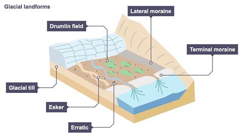
1. Drumlins
- Drumlins are oval-shaped, small hills.
- As the glacier moves it will erode more material than can be transported so the extra material gets deposited.
- There is a wide network of drumlins across Co Down and even under Strangford Lough.
2. Erratics
- These are pieces of rock, sometimes large boulders, that are transported by the ice and deposited on the ground when it melts.
- They are often found many miles from where that type of rock is located.
- For example, the Butterlump Stone near Newtownards is a piece of basalt that probably came from Scotland.
- A large piece of granite can also be found on top of Slieve Martin (near Rostrevor).
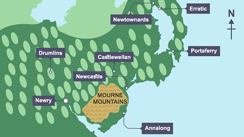
3. Moraines
- A moraine is a landform that occurs when there is deposition of the sediment carried by a glacier as it melts.
- The two main types of moraine are:
- Lateral moraine – where a ridge of sediment is found along the edge of a glaciated valley (For example along the Bloody Bridge River near Newcastle in the Mourne Mountains).
- Terminal moraine – a ridge of till material that runs along the front of the glacier and shows the furthest point of ice advance (for example between the Mourne Mountains and the coast near Annalong and the Silent Valley).
4. Esker
- A long and winding ridge of finer sediment that is formed by meltwater streams that flowed underneath the glacier (for example Esker ridge near Lisburn).
Quiz: Take the test
More on Rocks
Find out more by working through a topic
- count2 of 3
- count3 of 3